
Shawell地形图
点击地图以显示海拔。
关于这张地图
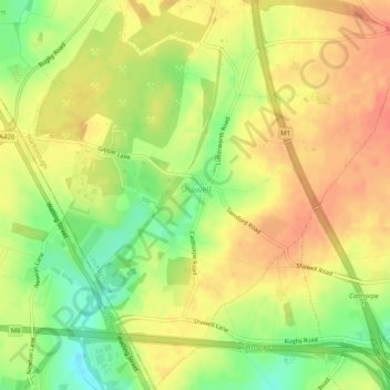
名称:Shawell地形图、海拔、地势。
地点:Shawell, Leicestershire, England, United Kingdom (52.40187 -1.22362 52.43262 -1.17308)
平均海拔:127 米
最低海拔:98 米
最高海拔:145 米
其他地形图
点击地图以查看其地形、其海拔和其地势。
Shellbrook
United Kingdom > England > Leicestershire > North West Leicestershire > Ashby-de-la-Zouch > Blackfordby
平均海拔:128 米
Illston on the Hill
United Kingdom > England > Leicestershire > Harborough > Illston on the Hill
平均海拔:158 米
Swannington
United Kingdom > England > Leicestershire > North West Leicestershire > Coalville
平均海拔:132 米