
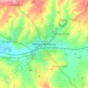
Melton Mowbray地形图
点击地图以显示海拔。
关于这张地图
名称:Melton Mowbray地形图、海拔、地势。
平均海拔:103 米
最低海拔:65 米
最高海拔:167 米
其他地形图
点击地图以查看其地形、其海拔和其地势。
Belvoir Castle
United Kingdom > England > Leicestershire > Melton > Belvoir
The traditional burial place of the Manners family was St Mary the Virgin's Church, Bottesford. Since elevation to the dukedom in 1703 most Dukes have been buried in the grounds of the mausoleum at Belvoir Castle. The mausoleum at Belvoir Castle was built by The 5th Duke of Rutland, following the death of his…
平均海拔:82 米
Bottesford
United Kingdom > England > Leicestershire > Melton
Bottesford's many listed buildings include the grade I listed 13th-century Church of St Mary the Virgin. There are two scheduled monuments within the village – Fleming's Bridge and the stone cross in the Market Place. The stocks and whipping post are Grade II listed. One of the Grade II listed buildings,…
平均海拔:39 米