
Quorn地形图
点击地图以显示海拔。
关于这张地图
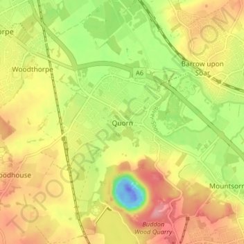
名称:Quorn地形图、海拔、地势。
平均海拔:55 米
最低海拔:-59 米
最高海拔:102 米
其他地形图
点击地图以查看其地形、其海拔和其地势。
Beacon Hill Country Park
United Kingdom > England > Leicestershire > Charnwood > Woodhouse Eaves
平均海拔:164 米
South Croxton
United Kingdom > England > Leicestershire > Charnwood > South Croxton
The highest point is the church, at 120 m above mean sea level. The lowest altitude is 85 m by the Queniborough Brook.
平均海拔:108 米
Bradgate Park
United Kingdom > England > Leicestershire > Charnwood > Newtown Linford
Overlying the Beacon Hill Formation, but found a little further down the hillside to the south, are the Bradgate Formation beds, the most notable of which is the Sliding Stone Slump Breccia rocks. Forming a line of crags below Old John, these are laminated mudstones, with layers of sandstone, mainly of…
平均海拔:126 米
Beeby
United Kingdom > England > Leicestershire > Charnwood
The physical and historical development of the hamlet has been strongly influenced by the local topography and its relative isolation. Beeby is situated within an established agricultural landscape largely in pastoral use. Until 1904 the east-west route was the only route through the hamlet, which was referred…
平均海拔:101 米
Top Town Plantation
United Kingdom > England > Leicestershire > Charnwood > Walton on the Wolds
平均海拔:85 米