
Glenfield地形图
点击地图以显示海拔。
关于这张地图
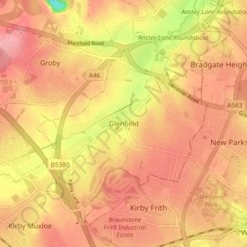
名称:Glenfield地形图、海拔、地势。
平均海拔:88 米
最低海拔:18 米
最高海拔:120 米
其他地形图
点击地图以查看其地形、其海拔和其地势。
Beacon Hill Country Park
United Kingdom > England > Leicestershire > Charnwood > Woodhouse Eaves
平均海拔:164 米
Illston on the Hill
United Kingdom > England > Leicestershire > Harborough > Illston on the Hill
平均海拔:158 米
Ashby de la Zouch Canal
United Kingdom > England > Leicestershire > North West Leicestershire > Moira
平均海拔:100 米
Swannington
United Kingdom > England > Leicestershire > North West Leicestershire > Coalville
平均海拔:132 米
Kimcote and Walton
United Kingdom > England > Leicestershire > Harborough > Kimcote and Walton
平均海拔:144 米
South Croxton
United Kingdom > England > Leicestershire > Charnwood > South Croxton
The highest point is the church, at 120 m above mean sea level. The lowest altitude is 85 m by the Queniborough Brook.
平均海拔:108 米