
Dauin地形图
点击地图以显示海拔。
关于这张地图
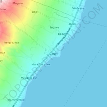
名称:Dauin地形图、海拔、地势。
地点:Dauin, Negros Oriental, Central Visayas, 6217, Philippines (9.14972 123.22577 9.22972 123.30577)
平均海拔:56 米
最低海拔:0 米
最高海拔:386 米
其他地形图
点击地图以查看其地形、其海拔和其地势。
Pamplona
Mountain ridges overlooking the plains of Pamplona, can be an object for viewers of scenic beauties. Nabalabag ridge, located at an elevation of 800 m above sea level at barangay San Isidro, overlooks on the west at municipalities of Bayawan and Santa Catalina and in the east, with the town of Pamplona, Tanjay…
平均海拔:339 米
Valencia
Valencia occupies an area of 14,749 hectares (36,450 acres), 35% of which are classified as plains. The town is 65% mountainous, with elevation averaging from 200 to 500 metres (660 to 1,640 ft) above sea level, with the top of Mount Talinis at an elevation of 1,903 metres (6,243 ft) along the municipal…
平均海拔:367 米
Santa Catalina
The topography of Santa Catalina is predominantly slightly rolling hills (70% of its area), 25% is flat, and the remainder is steep terrain. There are 8 rivers and 27 springs. Santa Catalina is 94 kilometres (58 mi) from Dumaguete.
平均海拔:142 米
Santa Catalina
The topography of Santa Catalina is predominantly slightly rolling hills (70% of its area), 25% is flat, and the remainder is steep terrain. There are 8 rivers and 27 springs.
平均海拔:142 米
Dumaguete
As a coastal city, it is bounded on the east by the Bohol Sea and the Tañon Strait, serving as a natural border of southeastern Negros Island Region to the neighboring Central Visayas. The city's topography is generally flat from two to six kilometers from the shoreline. It slopes gently upwards to the…
平均海拔:56 米
Valencia
Valencia occupies an area of 14,749 hectares (36,450 acres), 35% of which are classified as plains. The town is 65% mountainous, with elevation averaging from 200 to 500 metres (660 to 1,640 ft) above sea level, with the top of Mount Talinis at an elevation of 1,903 metres (6,243 ft) along the municipal…
平均海拔:367 米
Pamplona
Mountain ridges overlooking the plains of Pamplona, can be an object for viewers of scenic beauties. Nabalabag ridge, located at an elevation of 800 m above sea level at barangay San Isidro, overlooks on the west at municipalities of Bayawan and Santa Catalina and in the east, with the town of Pamplona, Tanjay…
平均海拔:342 米
Valencia
Valencia occupies an area of 14,749 hectares (36,450 acres), 35% of which are classified as plains. The town is 65% mountainous, with elevation averaging from 200 to 500 metres (660 to 1,640 ft) above sea level, with the top of Mount Talinis at an elevation of 1,903 metres (6,243 ft) along the municipal…
平均海拔:367 米
Dumaguete
As a coastal city, it is bounded on the east by the Bohol Sea and the Tañon Strait, serving as a natural border of the southeastern border of Negros Oriental. The city's topography is generally flat from two to six kilometers from the shoreline. It slopes gently upwards to the adjoining municipality of…
平均海拔:56 米
Dumaguete
As a coastal city, it is bounded on the east by the Bohol Sea and the Tañon Strait, serving as a natural border of southeastern Negros Island Region to the neighboring Central Visayas. The city's topography is generally flat from two to six kilometers from the shoreline. It slopes gently upwards to the…
平均海拔:56 米