
South County地形图
点击地图以显示海拔。
South County
According to the U.S. Census Bureau, the county has a total area of 563 square miles (1,460 km2), of which 329 square miles (850 km2) is land and 234 square miles (610 km2) (41%) is water. It is the largest county in Rhode Island by total area. The county's topography ranges from flat along the shoreline to gently rolling hills farther inland. The highest point is a large area approximately 560 feet (171 m) above sea level in the Exeter neighborhood of Black Plain; the lowest point is sea level along the coast. The northern boundary west of Davisville is approximately 41.60°N. The western boundary north of Westerly is approximately 71.79°W.
关于这张地图
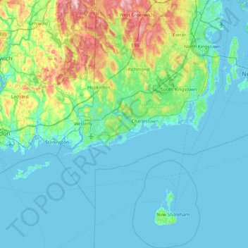
名称:South County地形图、海拔、地势。
地点:South County, Rhode Island, United States (41.09583 -71.90743 41.65531 -71.38209)
平均海拔:30 米
最低海拔:-5 米
最高海拔:196 米
其他地形图
点击地图以查看其地形、其海拔和其地势。
Jerimoth Hill
United States > Rhode Island > Providence County > Foster
The hill is located on Route 101 in Foster, a half mile from the Connecticut line. To ascend the summit, for which there is a sign, there is a 0.3-mile (480 m) long trail that has a mere 10-foot (3.0 m) elevation gain. The hill is 812 feet (247 m) high and is located 15 miles (24 km) west of Providence, Rhode…
平均海拔:216 米
Diamond Hill Park
United States > Rhode Island > Providence County > Cumberland > Diamond Hill
平均海拔:83 米
Jerimoth Hill
United States > Rhode Island > Providence County > Foster
The hill is located on Route 101 in Foster, a half mile from the Connecticut line. To ascend the summit, for which there is a sign, there is a .3-mile (480 m) long trail that has a mere 10-foot (3.0 m) elevation gain. The hill is 812 feet (247 m) high and is located 15 miles (24 km) west of Providence, Rhode…
平均海拔:216 米