
Jerimoth Hill地形图
点击地图以显示海拔。
Jerimoth Hill
The hill is located on Route 101 in Foster, a half mile from the Connecticut line. To ascend the summit, for which there is a sign, there is a .3-mile (480 m) long trail that has a mere 10-foot (3.0 m) elevation gain. The hill is 812 feet (247 m) high and is located 15 miles (24 km) west of Providence, Rhode Island, and 35 miles (56 km) east of Willimantic, Connecticut.
关于这张地图
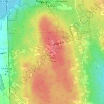
名称:Jerimoth Hill地形图、海拔、地势。
平均海拔:216 米
最低海拔:176 米
最高海拔:247 米