
Mosside地形图
点击地图以显示海拔。
关于这张地图
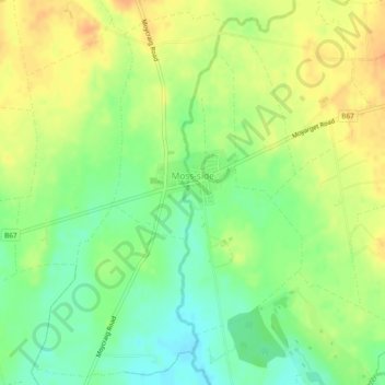
名称:Mosside地形图、海拔、地势。
地点:Mosside, Northern Ireland, United Kingdom (55.14372 -6.41213 55.16380 -6.39679)
平均海拔:62 米
最低海拔:44 米
最高海拔:78 米
其他地形图
点击地图以查看其地形、其海拔和其地势。
Derry/Londonderry
United Kingdom > Northern Ireland > County Londonderry
Derry is characterised by its distinctively hilly topography. The River Foyle forms a deep valley as it flows through the city, making Derry a place of very steep streets and sudden, startling views. The original walled city of Londonderry lies on a hill on the west bank of the River Foyle. In the past, the…
平均海拔:88 米
Newcastle
United Kingdom > Northern Ireland
In 1910 Harry Ferguson flew a small plane across Newcastle beach in one of the first engine powered flights by aircraft in Ireland. He completed the flight in an attempt to win a £100 prize offered by the town for the first powered flight along the strand. His first take off ended badly, but according to a…
平均海拔:115 米
Derry/Londonderry
United Kingdom > Northern Ireland > County Londonderry
Derry is characterised by its distinctively hilly topography. The River Foyle forms a deep valley as it flows through the city, giving it a steep topography. The original walled city of Londonderry lies on a hill on the west bank of the River Foyle. In the past, the river branched and enclosed this hill as an…
平均海拔:88 米