点击地图以显示海拔。
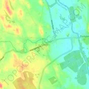
名称:Clady地形图、海拔、地势。
地点:Clady, Glenone, Mid-Ulster District Council, County Londonderry, Northern Ireland, BT44 8LH, United Kingdom (54.84961 -6.52842 54.88961 -6.48842)
平均海拔:30 米
最低海拔:10 米
最高海拔:63 米
点击地图以查看其地形、其海拔和其地势。
United Kingdom > Northern Ireland > County Londonderry
平均海拔:47 米
平均海拔:101 米
平均海拔:112 米
United Kingdom > Northern Ireland > County Londonderry > Derry/Londonderry
平均海拔:19 米
平均海拔:46 米
平均海拔:21 米
平均海拔:73 米
平均海拔:33 米
United Kingdom > Northern Ireland > County Londonderry > Londonderry/Derry
平均海拔:61 米