
Cabiao地形图
点击地图以显示海拔。
关于这张地图
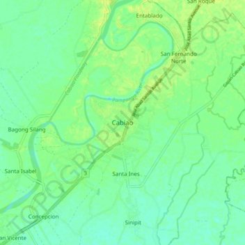
名称:Cabiao地形图、海拔、地势。
地点:Cabiao, Nueva Ecija, Central Luzon, 3107, Philippines (15.21127 120.81679 15.29127 120.89679)
平均海拔:13 米
最低海拔:5 米
最高海拔:21 米
其他地形图
点击地图以查看其地形、其海拔和其地势。
Pantabangan Dam
Philippines > Nueva Ecija > Pantabangan > Fatima
The dam is a 107 m (351 ft) tall and 1,615 m (5,299 ft) long embankment-type with 12,000,000 cu yd (9,174,658 m3) of homogeneous earth-fill and an impervious core. The crest of the dam is 12 m (39 ft) wide while the widest part of its base is 535 m (1,755 ft). The dam's crest sits at an elevation of 232 m (761…
平均海拔:210 米
Licab
About 155 kilometres (96 mi) north of Metro Manila, Licab lies in one of the lowest portions of the province with an average elevation of 24 metres (79 ft), experiencing flooding in all but one of its 11 barangays during rainy season.
平均海拔:22 米
Licab
About 155 kilometres (96 mi) north of Metro Manila, Licab lies in one of the lowest portions of the province with an average elevation of 24 metres (79 ft), experiencing flooding in all but one of its 11 barangays during rainy season.
平均海拔:22 米
San Jose
The city of San Jose lies at 15° 47' North, 120° 59' East in Central Luzon. The estimated elevation at these coordinates is approximately 109.9 meters or 360.4 feet above mean sea level. The city has two pronounced seasons, rainy season from the months of May to November and the dry season in the remaining…
平均海拔:147 米
Lupao
Lupao belongs to the first type of climate in the Philippines. This type of climate has two (2) pronounced seasons: dry from the month of November to April and Wet during the rest of the year. This type of climate is typically hot, humid and tropical and is generally affected by the neighboring topography and…
平均海拔:175 米
Muñoz
Muñoz is situated 30 kilometres (19 mi) from Cabanatuan, 44 kilometres (27 mi) from Palayan, and 146 kilometres (91 mi) north of the capital Manila. Due to its rich topography and tropical climate, it is now home to agricultural research and technology centers, committed to the production of information and…
平均海拔:72 米
Pantabangan Dam
Philippines > Nueva Ecija > Pantabangan > Fatima
The dam is a 107 m (351 ft) tall and 1,615 m (5,299 ft) long embankment-type with 12,000,000 cu yd (9,174,658 m3) of homogeneous earth-fill and an impervious core. The crest of the dam is 12 m (39 ft) wide while the widest part of its base is 535 m (1,755 ft). The dam's crest sits at an elevation of 232 m (761…
平均海拔:210 米
Muñoz
It is situated 30 kilometres (19 mi) from Cabanatuan, 44 kilometres (27 mi) from Palayan, and 146 kilometres (91 mi) north of the capital Manila. Due to its rich topography and tropical climate, it is now home to agricultural research and technology centers, committed to the production of information and…
平均海拔:72 米
Muñoz
Muñoz is situated 30 kilometres (19 mi) from Cabanatuan, 44 kilometres (27 mi) from Palayan, and 146 kilometres (91 mi) north of the capital Manila. Due to its rich topography and tropical climate, it is now home to agricultural research and technology centers, committed to the production of information and…
平均海拔:72 米
Lupao
Lupao belongs to the first type of climate in the Philippines. This type of climate has two (2) pronounced seasons: dry from the month of November to April and Wet during the rest of the year. This type of climate is typically hot, humid and tropical and is generally affected by the neighboring topography and…
平均海拔:175 米
Muñoz
Muñoz is situated 30 kilometres (19 mi) from Cabanatuan, 44 kilometres (27 mi) from Palayan, and 146 kilometres (91 mi) north of the capital Manila. Due to its rich topography and tropical climate, it is now home to agricultural research and technology centers, committed to the production of information and…
平均海拔:72 米
San Jose
The city of San Jose lies at 15° 47' North, 120° 59' East in Central Luzon. The estimated elevation at these coordinates is approximately 109.9 meters or 360.4 feet above mean sea level.
平均海拔:147 米
Talavera
The municipality's terrain is relatively flat, with slope ranging from 0 to 3%. Due to the flat topography, the land is suited for agricultural, commercial or industrial development. It is bordered by Cabanatuan, Llanera, Muñoz, Aliaga, General Mamerto Natividad, Santo Domingo and San Jose.
平均海拔:49 米