
Cabiao地形图
点击地图以显示海拔。
关于这张地图
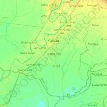
名称:Cabiao地形图、海拔、地势。
地点:Cabiao, Nueva Ecija, Central Luzon, 3107, Philippines (15.17552 120.76860 15.29356 120.91074)
平均海拔:11 米
最低海拔:1 米
最高海拔:23 米
其他地形图
点击地图以查看其地形、其海拔和其地势。
San Jose
The city of San Jose lies at 15° 47' North, 120° 59' East in Central Luzon. The estimated elevation at these coordinates is approximately 109.9 meters or 360.4 feet above mean sea level.
平均海拔:175 米
General Tinio
Farming is the livelihood of majority of the residents. Even though located at the foot of the Sierra Madre Mountain Ridges, the topography is generally plain ideal to agricultural products such as palay and vegetables. A number of poultry broiler contract growers are located in the municipality. Other…
平均海拔:54 米
Muñoz
Muñoz is situated 30 kilometres (19 mi) from Cabanatuan, 44 kilometres (27 mi) from Palayan, and 146 kilometres (91 mi) north of the capital Manila. Due to its rich topography and tropical climate, it is now home to agricultural research and technology centers, committed to the production of information and…
平均海拔:86 米
El Pobre Tanawan View Deck
Philippines > Nueva Ecija > Palayan > Bagong Buhay > Dos Cientos
平均海拔:201 米
Pantabangan Dam
Philippines > Nueva Ecija > Pantabangan > Fatima
The dam is a 107 m (351 ft) tall and 1,615 m (5,299 ft) long embankment-type with 12,000,000 cu yd (9,174,658 m3) of homogeneous earth-fill and an impervious core. The crest of the dam is 12 m (39 ft) wide while the widest part of its base is 535 m (1,755 ft). The dam's crest sits at an elevation of 232 m (761…
平均海拔:210 米