
Eday地形图
点击地图以显示海拔。
关于这张地图
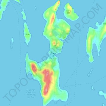
名称:Eday地形图、海拔、地势。
地点:Eday, Orkney Islands, Scotland, United Kingdom (59.13811 -2.82773 59.25045 -2.73360)
平均海拔:7 米
最低海拔:-1 米
最高海拔:100 米
其他地形图
点击地图以查看其地形、其海拔和其地势。
Ward Hill
United Kingdom > Scotland > Orkney Islands
Ward Hill is a hill on the island of Hoy in Orkney, Scotland. It lies at the north of the island between Moaness and Rackwick, and is the highest point in both Orkney and the Scottish Northern Isles at an elevation of 481 m (1,578 ft).
平均海拔:194 米