
Finstown地形图
点击地图以显示海拔。
关于这张地图
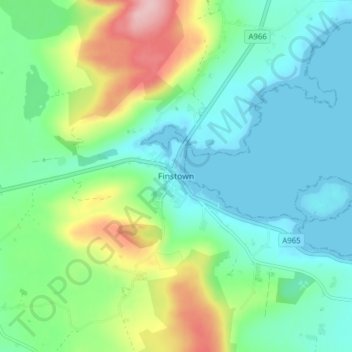
名称:Finstown地形图、海拔、地势。
地点:Finstown, Orkney Islands, Scotland, KW17 2EE, United Kingdom (58.98666 -3.13541 59.02666 -3.09541)
平均海拔:48 米
最低海拔:-3 米
最高海拔:172 米
其他地形图
点击地图以查看其地形、其海拔和其地势。
Orkney Islands
United Kingdom > Scotland > Orkney Islands
The southern group of islands surrounds Scapa Flow. Hoy, to the west, is the second largest of the Orkney Isles and Ward Hill at its northern end is the highest elevation in the archipelago. The Old Man of Hoy is a well-known seastack. Graemsay and Flotta are both linked by ferry to the Mainland and Hoy, and…
平均海拔:9 米
Sanday
United Kingdom > Scotland > Orkney Islands > Kettletoft
In the mid-17th century an annexe to Blaeu's Atlas Novus of Scotland recorded that Sanday's low lying topography meant that "shipwreck often occurs to those who sail there at night. The inhabitants of Sanday earnestly and often desire this to happen, so that they get a supply of material for fire from the…
平均海拔:2 米
South Ronaldsay
United Kingdom > Scotland > Orkney Islands
The cardinal points of the island are Ayre of Cara, by Churchill Barrier no. 4 (north), Grimness (east), Brough Ness, (south) and Hoxa Head, (west). The highest elevation is Ward Hill, which reaches 118 metres (387 ft). This name is common one in Orkney for the highest point on an island and comes from the…
平均海拔:12 米
Stronsay
United Kingdom > Scotland > Orkney Islands > Whitehall
Stronsay (/ˈstrɒnziː/) is an island in Orkney, Scotland. It is known as Orkney's 'Island of Bays', owing to an irregular shape with miles of coastline, with three large bays separated by two isthmuses: St Catherine's Bay to the west, the Bay of Holland to the south and Mill Bay to the east. Stronsay is…
平均海拔:4 米
Orkney Islands
United Kingdom > Scotland > Orkney Islands
The southern group of islands surrounds Scapa Flow. Hoy, to the west, is the second largest of the Orkney Isles and Ward Hill at its northern end is the highest elevation in the archipelago. The Old Man of Hoy is a well-known seastack. Graemsay and Flotta are both linked by ferry to the Mainland and Hoy, and…
平均海拔:9 米
Sanday
United Kingdom > Scotland > Orkney Islands > Kettletoft
In the mid-17th century an annexe to Blaeu's Atlas Novus of Scotland recorded that Sanday's low lying topography meant that "shipwreck often occurs to those who sail there at night. The inhabitants of Sanday earnestly and often desire this to happen, so that they get a supply of material for fire from the…
平均海拔:2 米