
Lake Bay地形图
点击地图以显示海拔。
关于这张地图
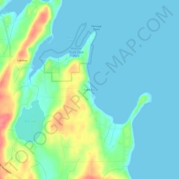
名称:Lake Bay地形图、海拔、地势。
地点:Lake Bay, Pierce County, Washington, United States (47.23176 -122.75847 47.27176 -122.71847)
平均海拔:16 米
最低海拔:-1 米
最高海拔:68 米
其他地形图
点击地图以查看其地形、其海拔和其地势。
Tacoma
United States > Washington > Pierce County
Tacoma is at 47°14′29″N 122°27′34″W / 47.24139°N 122.45944°W / 47.24139; -122.45944 (47.241371, −122.459389). Its official elevation is 381 feet (116 m), varying between sea level and about 500 feet (150 m).
平均海拔:67 米
Tacoma
United States > Washington > Pierce County
Tacoma is at 47°14′29″N 122°27′34″W / 47.24139°N 122.45944°W / 47.24139; -122.45944 (47.241371, −122.459389). Its official elevation is 381 feet (116 m), varying between sea level and about 500 feet (150 m).
平均海拔:67 米
Mount Rainier National Park
United States > Washington > Pierce County
Mount Rainier National Park is an American national park located in southeast Pierce County and northeast Lewis County in Washington state. The park was established on March 2, 1899 as the fifth national park in the United States, preserving 236,381 acres (369.3 sq mi; 956.6 km2) including all of Mount…
平均海拔:1,412 米
Tacoma
United States > Washington > Pierce County
Tacoma is at 47°14′29″N 122°27′34″W / 47.24139°N 122.45944°W / 47.24139; -122.45944 (47.241371, −122.459389). Its official elevation is 381 feet (116 m), varying between sea level and about 500 feet (150 m).
平均海拔:67 米
Puyallup
United States > Washington > Pierce County
Downtown Puyallup and nearby neighborhoods lie within the hazard zone for lahars that could be produced in a moderate or large eruption of nearby Mount Rainier. The city's position on the Puyallup River is downstream of the western flank of Mount Rainier, which has the highest potential for producing…
平均海拔:67 米
Tacoma
United States > Washington > Pierce County
Tacoma has an official elevation of 381 feet (116 m), varying between sea level and about 500 feet (150 m).
平均海拔:67 米
Puyallup
United States > Washington > Pierce County
Downtown Puyallup and nearby neighborhoods lie within the hazard zone for lahars that could be produced in a moderate or large eruption of nearby Mount Rainier. The city's position on the Puyallup River is downstream of the western flank of Mount Rainier, which has the highest potential for producing…
平均海拔:67 米
Tacoma
United States > Washington > Pierce County
Tacoma is at 47°14′29″N 122°27′34″W / 47.24139°N 122.45944°W / 47.24139; -122.45944 (47.241371, −122.459389). Its official elevation is 381 feet (116 m), varying between sea level and about 500 feet (150 m).
平均海拔:67 米
Greenwater
United States > Washington > Pierce County
Greenwater is located at the confluence of the Greenwater and White Rivers, at an approximate elevation of 1,700 feet (520 m) above sea level.
平均海拔:655 米
Puyallup
United States > Washington > Pierce County
Downtown Puyallup and nearby neighborhoods lie within the hazard zone for lahars that could be produced in a moderate or large eruption of nearby Mount Rainier. The city's position on the Puyallup River is downstream of the western flank of Mount Rainier, which has the highest potential for producing…
平均海拔:67 米
Tacoma
United States > Washington > Pierce County
Tacoma has an official elevation of 381 feet (116 m), varying between sea level and about 500 feet (150 m).
平均海拔:67 米