
Sedro-Woolley地形图
点击地图以显示海拔。
关于这张地图
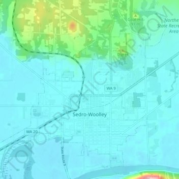
名称:Sedro-Woolley地形图、海拔、地势。
地点:Sedro-Woolley, Skagit County, Washington, United States (48.48928 -122.28031 48.53524 -122.20130)
平均海拔:33 米
最低海拔:8 米
最高海拔:197 米
其他地形图
点击地图以查看其地形、其海拔和其地势。
Sahale Mountain
United States > Washington > Skagit County
The North Cascades features some of the most rugged topography in the Cascade Range with craggy peaks and ridges, deep glacial valleys, and granite spires. Geological events occurring many years ago created the diverse topography and drastic elevation changes over the Cascade Range leading to various climate…
平均海拔:2,132 米
Black Peak
United States > Washington > Skagit County
Black Peak is a tall peak in the Cascade Range in the U.S. state of Washington. It lies in the Stephen Mather Wilderness and North Cascades National Park. At 8,975 feet (2,736 m) in elevation it is the 20th-highest peak in Washington. Black Peaks's prominence is 3,450 feet (1,050 m), making it the 35th-most…
平均海拔:2,098 米