
Tarlac City地形图
点击地图以显示海拔。
关于这张地图
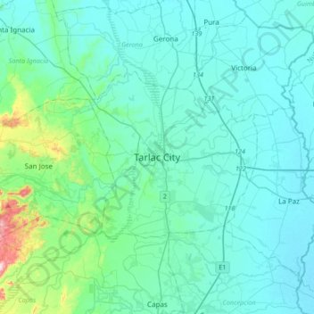
名称:Tarlac City地形图、海拔、地势。
地点:Tarlac City, Tarlac, Central Luzon, Philippines (15.32612 120.42935 15.64612 120.74935)
平均海拔:56 米
最低海拔:13 米
最高海拔:376 米
其他地形图
点击地图以查看其地形、其海拔和其地势。
Camiling
Mostly of plain topography but some parts are hilly to mountainous in which the barangays of Papaac, Bacsay, Birbira and Cayasan, to name a few. The deeper part of the mountains can be described as a place where wild animals live, such as deer, Toddy cat (Musang), wild boar (Baboy ramo), Monitor lizard…
平均海拔:32 米
Pura
Pura, just like any other town in the province of the Tarlac has two (2) pronounced seasons. The wet season that starts from May up to lasts up to September and dry from the month of October to April. This type of climate is typically hot, humid, and tropical and is generally affected by the neighboring…
平均海拔:23 米
Camiling
Mostly of plain topography but some parts are hilly to mountainous in which the barangays of Papaac, Bacsay, Birbira and Cayasan, to name a few. The deeper part of the mountains can be described as a place where wild animals live, such as deer, Toddy cat (Musang), wild boar (Baboy ramo), Monitor lizard…
平均海拔:32 米