Guildford地形图
点击地图以显示海拔。
关于这张地图
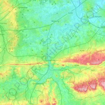
名称:Guildford地形图、海拔、地势。
地点:Guildford, Surrey, 英格兰 / 英格蘭, 英国 / 英國 (51.17319 -0.74834 51.33152 -0.38717)
平均海拔:74 米
最低海拔:12 米
最高海拔:256 米
其他地形图
点击地图以查看其地形、其海拔和其地势。

点击地图以显示海拔。
名称:Guildford地形图、海拔、地势。
地点:Guildford, Surrey, 英格兰 / 英格蘭, 英国 / 英國 (51.17319 -0.74834 51.33152 -0.38717)
平均海拔:74 米
最低海拔:12 米
最高海拔:256 米
点击地图以查看其地形、其海拔和其地势。