Surrey地形图
点击地图以显示海拔。
关于这张地图
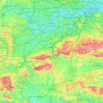
名称:Surrey地形图、海拔、地势。
地点:Surrey, 英格兰 / 英格蘭, 英国 / 英國 (51.07150 -0.84893 51.47156 0.05822)
平均海拔:69 米
最低海拔:-1 米
最高海拔:289 米
其他地形图
点击地图以查看其地形、其海拔和其地势。

点击地图以显示海拔。
名称:Surrey地形图、海拔、地势。
地点:Surrey, 英格兰 / 英格蘭, 英国 / 英國 (51.07150 -0.84893 51.47156 0.05822)
平均海拔:69 米
最低海拔:-1 米
最高海拔:289 米
点击地图以查看其地形、其海拔和其地势。