
Finnis地形图
点击地图以显示海拔。
关于这张地图
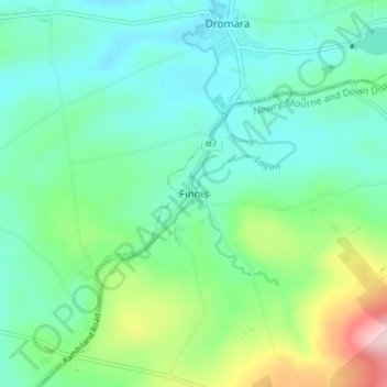
名称:Finnis地形图、海拔、地势。
平均海拔:184 米
最低海拔:112 米
最高海拔:411 米
其他地形图
点击地图以查看其地形、其海拔和其地势。
County Antrim
United Kingdom > Northern Ireland
A large portion of Antrim is hilly, especially in the east, where the highest elevations are attained. The range runs north and south, and, following this direction, the highest points are Knocklayd 514 m (1,690 ft), Slieveanorra 508 m (1,670 ft), Trostan 550 m (1,800 ft), Slemish 437 m (1,430 ft), Agnew's…
平均海拔:70 米