
Blyth地形图
互动地图
点击地图以显示海拔。
关于这张地图
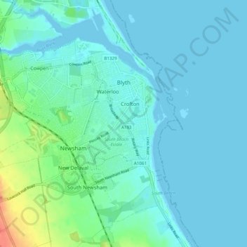
名称:Blyth地形图、海拔、地势。
地点:Blyth, Northumberland, North of Tyne, 英格兰 / 英格蘭, 英国 / 英國 (55.09630 -1.58667 55.13922 -1.48934)
平均海拔:8 米
最低海拔:-2 米
最高海拔:47 米
其他地形图
点击地图以查看其地形、其海拔和其地势。
Cramlington
英国 / 英國 > 英格兰 / 英格蘭 > Northumberland
Cramlington, Northumberland, North of Tyne, 英格兰 / 英格蘭, 英国 / 英國
平均海拔:53 米
Berwick-upon-Tweed
英国 / 英國 > 英格兰 / 英格蘭 > Northumberland
Berwick-upon-Tweed, Northumberland, North of Tyne, 英格兰 / 英格蘭, 英国 / 英國
平均海拔:33 米