Cramlington地形图
点击地图以显示海拔。
关于这张地图
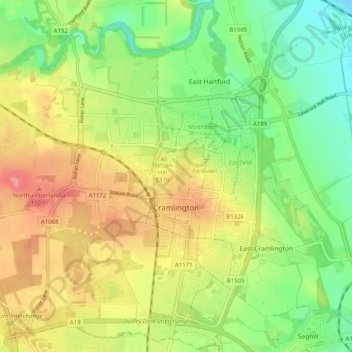
名称:Cramlington地形图、海拔、地势。
地点:Cramlington, Northumberland, North of Tyne, 英格兰 / 英格蘭, 英国 / 英國 (55.06243 -1.64709 55.11888 -1.54667)
平均海拔:53 米
最低海拔:15 米
最高海拔:98 米

点击地图以显示海拔。
名称:Cramlington地形图、海拔、地势。
地点:Cramlington, Northumberland, North of Tyne, 英格兰 / 英格蘭, 英国 / 英國 (55.06243 -1.64709 55.11888 -1.54667)
平均海拔:53 米
最低海拔:15 米
最高海拔:98 米