
Vida地形图
点击地图以显示海拔。
关于这张地图
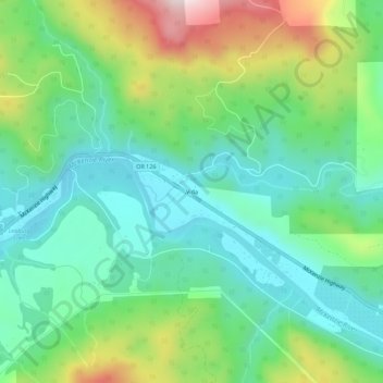
名称:Vida地形图、海拔、地势。
地点:Vida, Lane County, Oregon, United States (44.12586 -122.58977 44.16586 -122.54977)
平均海拔:366 米
最低海拔:217 米
最高海拔:703 米
其他地形图
点击地图以查看其地形、其海拔和其地势。
Eugene
United States > Oregon > Lane County
Eugene is characterized by a varied topography that contributes to its picturesque landscapes. The city sits at an average elevation of about 426 feet (130 meters) and is nestled within the Willamette Valley, surrounded by the foothills of the Cascade Mountains to the east, which rise significantly in…
平均海拔:163 米
Lowell
United States > Oregon > Lane County
The climate of Lowell differs slightly from that of Eugene, which is at lower elevation. Lowell receives 8 inches (20 cm) more of rain and 2 inches (51 mm) more of snow per year than Eugene. In central Lane County, that two inches is significant considering the lack of snow. The higher areas of the town…
平均海拔:261 米
Oakridge
United States > Oregon > Lane County
The city was originally a community called "Hazeldell", and its post office was established on July 26, 1888. When a station on the Southern Pacific Railroad opened in May 1912, it was named "Oak Ridge" by a railroad executive for the surrounding topography, and on July 19 of that year the name was changed to…
平均海拔:465 米
Eugene
United States > Oregon > Lane County
According to the United States Census Bureau, the city has a total area of 43.74 square miles (113.29 km2), of which 43.72 square miles (113.23 km2) is land and 0.02 square miles (0.05 km2) is water. Eugene is at an elevation of 426 feet (130 m).
平均海拔:163 米
Oakridge
United States > Oregon > Lane County
The city was originally a community called "Hazeldell", and its post office was established on July 26, 1888. When a station on the Southern Pacific Railroad opened in May 1912, it was named "Oak Ridge" by a railroad executive for the surrounding topography, and on July 19 of that year the name was changed to…
平均海拔:465 米
Eugene
United States > Oregon > Lane County
According to the United States Census Bureau, the city has a total area of 43.74 square miles (113.29 km2), of which 43.72 square miles (113.23 km2) is land and 0.02 square miles (0.05 km2) is water. Eugene is at an elevation of 426 feet (130 m).
平均海拔:163 米
Eugene
United States > Oregon > Lane County
According to the United States Census Bureau, the city has a total area of 43.74 square miles (113.29 km2), of which 43.72 square miles (113.23 km2) is land and 0.02 square miles (0.05 km2) is water. Eugene is at an elevation of 426 feet (130 m).
平均海拔:163 米
Oakridge
United States > Oregon > Lane County
The city was originally a community called "Hazeldell", and its post office was established on July 26, 1888. When a station on the Southern Pacific Railroad opened in May 1912, it was named "Oak Ridge" by a railroad executive for the surrounding topography, and on July 19 of that year the name was changed to…
平均海拔:465 米