
Cheshunt地形图
点击地图以显示海拔。
关于这张地图
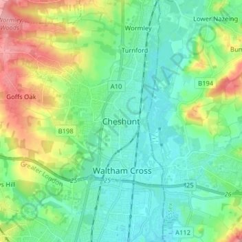
名称:Cheshunt地形图、海拔、地势。
平均海拔:43 米
最低海拔:14 米
最高海拔:115 米
其他地形图
点击地图以查看其地形、其海拔和其地势。
St Albans
United Kingdom > England > Hertfordshire > St Albans
St Albans was an ancient borough created following the dissolution of the monastery in 1539. It consisted of the ancient parish of St Albans (also known as the Abbey parish) and parts of St Michael and St Peter. The municipal corporation was reformed by the Municipal Corporations Act 1835 and the boundary was…
平均海拔:100 米
St Albans
United Kingdom > England > Hertfordshire
St Albans was an ancient borough created following the dissolution of the monastery in 1539. It consisted of the ancient parish of St Albans (also known as the Abbey parish) and parts of St Michael and St Peter. The municipal corporation was reformed by the Municipal Corporations Act 1835 and the boundary was…
平均海拔:107 米
Bishop's Stortford
United Kingdom > England > Hertfordshire > East Hertfordshire
Stortford, along with the rest of Britain, has a temperate maritime climate, with cool summers and mild winters. The nearest weather station for which averages and extremes are available is Stansted Airport, about 2+1⁄2 miles (4 kilometres) due east of Stortford's town centre. Located at an elevation of over…
平均海拔:83 米
Berkhamsted
United Kingdom > England > Hertfordshire > Dacorum
The layout of Berkhamsted's centre is typical of a medieval market settlement: the linear High Street (aligned on the Akeman Street) forms the spine of the town (roughly aligned east–west), from which extend medieval burgage plots (to the north and south). The surviving burgage plot layout is the result of a…
平均海拔:142 米
St Albans
United Kingdom > England > Hertfordshire
The borough consisted of the ancient parish of St Albans (also known as the Abbey parish) and parts of the parishes of St Michael and St Peter. The borough was reformed by the Municipal Corporations Act 1835 to become a municipal borough, and the boundary was adjusted to additionally include part of the parish…
平均海拔:103 米
Gobions Pond
United Kingdom > England > Hertfordshire > Welwyn Hatfield > Brookmans Park > Swanley Bar
平均海拔:106 米
Knebworth Country Park
United Kingdom > England > Hertfordshire > North Hertfordshire > Knebworth
平均海拔:116 米
Furneux Pelham
United Kingdom > England > Hertfordshire > East Hertfordshire > Furneux Pelham
平均海拔:113 米
The Rookery
United Kingdom > England > Hertfordshire > Three Rivers > Abbots Langley > Langleybury
平均海拔:92 米
Stocking Pelham
United Kingdom > England > Hertfordshire > East Hertfordshire > Stocking Pelham
平均海拔:114 米
Stanborough Park
United Kingdom > England > Hertfordshire > Welwyn Hatfield > Hatfield > Stanborough
平均海拔:79 米
Sawbridgeworth
United Kingdom > England > Hertfordshire > East Hertfordshire > Sawbridgeworth
平均海拔:67 米