
Palm Springs地形图
点击地图以显示海拔。
Palm Springs
One possible origin of palm in the place name comes from early Spanish explorers who referred to the area as La Palma de la Mano de Dios or "The Palm of God's hand". The earliest use of the name "Palm Springs" is from United States Topographical Engineers who used the term in 1853 maps. According to William Bright, when the word "palm" appears in Californian place names, it usually refers to the native California fan palm, Washingtonia filifera, which is abundant in the Palm Springs area. Other early names were "Palmetto Spring" and "Big Palm Springs".
关于这张地图
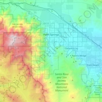
名称:Palm Springs地形图、海拔、地势。
地点:Palm Springs, Riverside County, California, United States (33.61242 -116.71209 33.93198 -116.44280)
平均海拔:859 米
最低海拔:41 米
最高海拔:3,277 米
其他地形图
点击地图以查看其地形、其海拔和其地势。
Colorado River
United States > California > Riverside County
The entire eastern boundary of the Colorado River Basin runs along the North American Continental Divide and is defined largely by the Rocky Mountains and the Rio Grande Basin. The Wind River Range in Wyoming marks the northern extent of the basin, and is separated from the Colorado Rockies by the endorheic…
平均海拔:93 米
Idyllwild-Pine Cove
United States > California > Riverside County
"Mile-high Idyllwild" is a mountain resort about one-mile (1,600 m) in altitude. Idyllwild is flanked by two large rock formations, Tahquitz Peak and Suicide Rock (also known as Lily Rock), which are famous in Southern California rock-climbing circles. It offers no skiing, so "the Hill" has been minimally…
平均海拔:1,746 米