
Dolores Hidalgo地形图
点击地图以显示海拔。
Dolores Hidalgo
It is located at 21°10′N 100°56′W / 21.17°N 100.93°W / 21.17; -100.93, at an elevation of about 1,980 meters (6,500 feet) above sea level. In the census of 2005 the city had a population of 54,843, while the municipality had 134,641 inhabitants. The city lies directly in the center of the municipality, which is 1,656 km2 (639 sq mi) in area and includes numerous small outlying communities, the largest of which is Río Laja with a population of 2,211 (2005 census).
关于这张地图
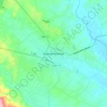
名称:Dolores Hidalgo地形图、海拔、地势。
地点:Dolores Hidalgo, Guanajuato, 37800, Mexico (21.11740 -100.97462 21.19740 -100.89462)
平均海拔:1,938 米
最低海拔:1,893 米
最高海拔:2,124 米