
Glacier Bay地形图
点击地图以显示海拔。
Glacier Bay
Glacier Bay is covered with 1,375 square miles (3,560 km2) of glaciers which accounts for 27% of the Park area with most glaciers originating in mountains with elevation range of 8,000–15,000 feet (2,400–4,600 m). There are over 50 named glaciers (both tidewater and terrestrial glaciers); 10 tide water glaciers – one on the east arm of the bay and all others on the west arm reach shorelines and calved) (literal meaning: "breaking off") to produce icebergs. Seven of these glaciers are reported to be active tidewater glaciers, which depict the calving phenomenon, which means that they break into icebergs and fall into the sea with thundering noise raising large waves. The McBride Glacier is the only tidewater glacier in the eastern arm at a distance of 40 nautical miles (74 km) from Bartlett Cove. Of the other glaciers on the western arm, Johns Hopkins Glacier is at the farthest end – 63 nautical miles (117 km) from the entrance to the bay while the Margerie Glacier is about 55 nautical miles (102 km) away.
关于这张地图
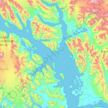
名称:Glacier Bay地形图、海拔、地势。
地点:Glacier Bay, Unorganized Borough, Alaska, United States (58.37114 -137.13268 59.09219 -135.79426)
平均海拔:402 米
最低海拔:-4 米
最高海拔:2,103 米
其他地形图
点击地图以查看其地形、其海拔和其地势。
Kasatochi Island
United States > Alaska > Unorganized Borough
Kasatochi Island is a member of the Aleutian Islands, which lie above a narrow ridge that separates the Bering Sea from the North Pacific. It lies at the Atka Pass northwest of the western tip of Atka Island and east of Great Sitkin Island. It is at 52.177° N latitude and 175.508° W longitude, with a summit…
平均海拔:53 米
Eagle Summit
United States > Alaska > Unorganized Borough
It was for this latter reason that engineers chose Eagle Summit as the route to build the Steese Highway, which connects Fairbanks, Alaska to the Yukon River at Circle. In 1927, just 11 years after Stuck became one of the first Americans to navigate Eagle Summit on dog sled, the highway was completed and road…
平均海拔:1,068 米