
La Paz地形图
点击地图以显示海拔。
La Paz
The city, in west-central Bolivia 68 km (42 mi) southeast of Lake Titicaca, is set in a canyon created by the Choqueyapu River. It is in a bowl-like depression, part of the Amazon basin, surrounded by the high mountains of the Altiplano. Overlooking the city is the towering, triple-peaked Illimani. Its peaks are always snow-covered and can be seen from many parts of the city. At an elevation of roughly 3,650 m (11,975 ft) above sea level, La Paz is the highest capital city in the world. Due to its altitude, La Paz has an unusual subtropical highland climate, with rainy summers and dry winters.
关于这张地图
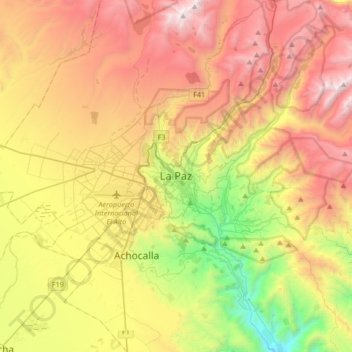
名称:La Paz地形图、海拔、地势。
地点:La Paz, Pedro Domingo Murillo, La Paz, 3278, Bolivia (-16.65555 -68.29362 -16.33555 -67.97362)
平均海拔:4,087 米
最低海拔:2,906 米
最高海拔:5,372 米
其他地形图
点击地图以查看其地形、其海拔和其地势。