Belfast地形图
点击地图以显示海拔。
关于这张地图
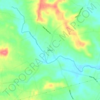
名称:Belfast地形图、海拔、地势。
地点:Belfast, Highland County, Ohio, United States (39.04285 -83.55242 39.08285 -83.51242)
平均海拔:267 米
最低海拔:241 米
最高海拔:313 米
其他地形图
点击地图以查看其地形、其海拔和其地势。

点击地图以显示海拔。
名称:Belfast地形图、海拔、地势。
地点:Belfast, Highland County, Ohio, United States (39.04285 -83.55242 39.08285 -83.51242)
平均海拔:267 米
最低海拔:241 米
最高海拔:313 米
点击地图以查看其地形、其海拔和其地势。