
Clun地形图
点击地图以显示海拔。
关于这张地图
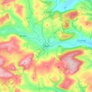
名称:Clun地形图、海拔、地势。
地点:Clun, Shropshire, England, SY7 8JP, United Kingdom (52.38118 -3.07006 52.46118 -2.99006)
平均海拔:284 米
最低海拔:156 米
最高海拔:447 米
其他地形图
点击地图以查看其地形、其海拔和其地势。
Shrewsbury
United Kingdom > England > Shropshire
Shrewsbury is about 14 miles (23 km) west of Telford, 43 miles (69 km) west of Birmingham and the West Midlands Conurbation, and about 153 miles (246 km) north-west of the capital, London. More locally, the town is to the east of Welshpool, with Bridgnorth and Kidderminster to the south-east. The border with…
平均海拔:69 米
Ludlow
United Kingdom > England > Shropshire
During the 12th century, the planned town of Ludlow was formed, in stages, the town providing a useful source of income for successive Marcher Lords, based on rents, fines, and tolls. They developed the town on a regular grid pattern, although this was adapted somewhat to match the local topography, from the…
平均海拔:108 米
Bridgnorth
United Kingdom > England > Shropshire
The town is in the Severn Valley, where the river passes through a relatively narrow valley with largely-wooded slopes. High Town, the part of the town sited on the west side of the Severn, is built on a notable promontory, at the southern end of which the castle was constructed, and is known as Castle Hill.…
平均海拔:80 米
Ludlow
United Kingdom > England > Shropshire
During the 12th century, the planned town of Ludlow was formed, in stages, the town providing a useful source of income for successive Marcher Lords, based on rents, fines, and tolls. They developed the town on a regular grid pattern, although this was adapted somewhat to match the local topography, from the…
平均海拔:108 米
Shrewsbury
United Kingdom > England > Shropshire
The town centre is partially built on a hill whose elevation is, at its highest, 246 feet (75 m) above sea level. The longest river in the United Kingdom, the River Severn, flows through the town, forming a meander around its centre. The Rea Brook is a small river that has its confluence with the Severn at…
平均海拔:69 米
Long Mynd
United Kingdom > England > Shropshire > Church Stretton
Long Mynd comprises a multitude of valleys, and the highest concentration lies along the eastern edge, near Church Stretton. Topographically, many of the larger valleys lie adjacent to each other and are aligned northwest to southeast. The main valleys include.
平均海拔:292 米
Bridgnorth
United Kingdom > England > Shropshire
The town is located in the Severn Valley, where the river passes through a relatively narrow valley with largely-wooded slopes. High Town, the part of the town sited on the west side of the Severn, is built on a notable promontory, at the southern end of which the castle was constructed, and is known as Castle…
平均海拔:80 米
Shropshire Hills National Landscape
United Kingdom > England > Shropshire
The Shropshire Hills, located in the Welsh Marches, are relatively high: the highest point in the county, Brown Clee Hill, near Ludlow, has an altitude of 540 metres (1,772 ft). This gives Shropshire the 13th highest hill per county in England. Titterstone Clee Hill, part of the Clee Hills, is nearly as high…
平均海拔:171 米
Bridgnorth
United Kingdom > England > Shropshire
The town is located in the Severn Valley, where the river passes through a relatively narrow valley with largely-wooded slopes. High Town, the part of the town sited on the west side of the Severn, is built on a notable promontory, at the southern end of which the castle was constructed, and is known as Castle…
平均海拔:80 米
Clungunford
United Kingdom > England > Shropshire > Clungunford
Clungunford lies at an elevation of between 130m and 145m above sea level.
平均海拔:180 米
Shrewsbury
United Kingdom > England > Shropshire
Shrewsbury is about 14 miles (23 km) west of Telford, 43 miles (69 km) west of Birmingham and the West Midlands Conurbation, and about 153 miles (246 km) north-west of the capital, London. More locally, the town is to the east of Welshpool, with Bridgnorth and Kidderminster to the south-east. The border with…
平均海拔:69 米