
Hindon地形图
点击地图以显示海拔。
关于这张地图
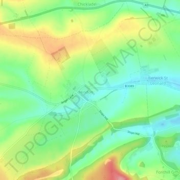
名称:Hindon地形图、海拔、地势。
地点:Hindon, Wiltshire, England, United Kingdom (51.07971 -2.14675 51.11102 -2.10952)
平均海拔:150 米
最低海拔:107 米
最高海拔:217 米
其他地形图
点击地图以查看其地形、其海拔和其地势。
Cley Hill
United Kingdom > England > Wiltshire
Cley Hill (grid reference ST838449) is a prominent hill to the west of Warminster in Wiltshire, England. Its summit has a commanding view of the Wiltshire / Somerset county boundary, at 244 metres (801 ft) elevation. The land is in Corsley parish and is owned by the National Trust.
平均海拔:157 米