点击地图以显示海拔。
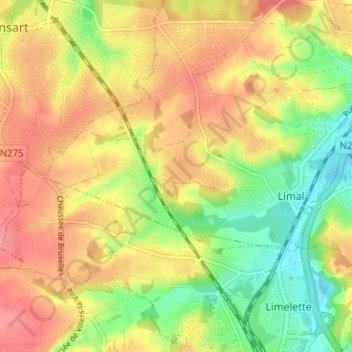
名称:Grandsart地形图、海拔、地势。
地点:Grandsart, Limal, Wavre, Nivelles, Brabant wallon, Wallonie, 1342, Belgique (50.67534 4.53301 50.71534 4.57301)
平均海拔:90 米
最低海拔:46 米
最高海拔:128 米
点击地图以查看其地形、其海拔和其地势。
Belgique > Brabant wallon > Nivelles > Wavre
平均海拔:85 米
平均海拔:81 米
平均海拔:86 米
平均海拔:83 米