
Hooker Falls地形图
点击地图以显示海拔。
关于这张地图
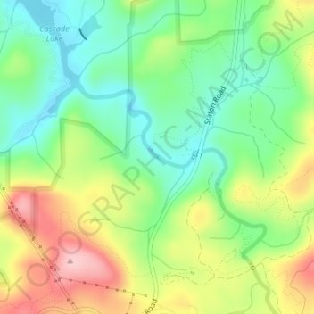
名称:Hooker Falls地形图、海拔、地势。
平均海拔:755 米
最低海拔:682 米
最高海拔:864 米
其他地形图
点击地图以查看其地形、其海拔和其地势。
Pisgah National Forest
United States > North Carolina > Transylvania County
The Pisgah National Forest covers 512,758 acres (801 sq mi; 2,075 km2) of mountainous terrain in the southern Appalachian Mountains, including parts of the Blue Ridge Mountains and Great Balsam Mountains. Elevations reach over 6,000 feet (1,800 m) and include some of the highest mountains in the eastern United…
平均海拔:752 米
Gorges State Park
United States > North Carolina > Transylvania County
Following the flood, local citizens eventually sold large land tracts in the Gorges to Singer Sewing Machine Company, which logged most of the land. Then, in the 1940s and 1950s, Singer sold the land to Duke Energy Corporation. The corporation purchased the land for its steep topography and high rainfall,…
平均海拔:682 米