
Salacoa地形图
点击地图以显示海拔。
关于这张地图
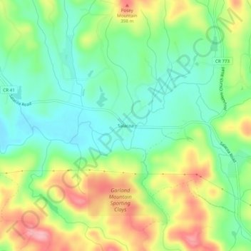
名称:Salacoa地形图、海拔、地势。
地点:Salacoa, Cherokee County, Georgia, United States (34.37065 -84.63132 34.41065 -84.59132)
平均海拔:326 米
最低海拔:272 米
最高海拔:410 米
其他地形图
点击地图以查看其地形、其海拔和其地势。
Ball Ground
United States > Georgia > Cherokee County
According to the United States Census Bureau as of 2020, Ball Ground has a total area of 6.3 sq mi (16 km2), of which 0.04 sq mi (0.10 km2), or 0.63%, is water. The city's elevation averages around 1,100 ft (340 m) above sea level, ranging from just over 1,000 ft (300 m) in the valleys to around 1,200 ft (370…
平均海拔:331 米