
Kyle地形图
点击地图以显示海拔。
关于这张地图
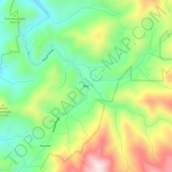
名称:Kyle地形图、海拔、地势。
地点:Kyle, Macon County, North Carolina, 28781, United States (35.20120 -83.63544 35.24120 -83.59544)
平均海拔:1,074 米
最低海拔:861 米
最高海拔:1,404 米
其他地形图
点击地图以查看其地形、其海拔和其地势。
Franklin
United States > North Carolina > Macon County
Franklin is characterized by its mountainous terrain, lying within the picturesque Appalachian Mountains. The area features rugged landscapes with elevations typically ranging from around 2,000 to 4,000 feet, creating dramatic vistas and deep valleys. The Little Tennessee River winds through the region, adding…
平均海拔:675 米
Highlands
United States > North Carolina > Macon County
Highlands was founded in 1875 after its two founders, Samuel Truman Kelsey and Clinton Carter Hutchinson, drew lines from Chicago to Savannah and from New Orleans to New York City. They felt that the place where these lines met would eventually become a great trading center and commercial crossroads. Highlands…
平均海拔:1,116 米
Franklin
United States > North Carolina > Macon County
The height of the falls is given as 200 ft (61 m) in Kevin Adams' book, North Carolina Waterfalls and 250 ft (77.1 m) by NCWaterfalls.com. However, Google Earth gives a height (based on the elevation of the water at the top of the falls and the elevation of the plunge pool at the bottom of the falls) of 137 ft…
平均海拔:675 米