Sandy Bottom地形图
点击地图以显示海拔。
关于这张地图
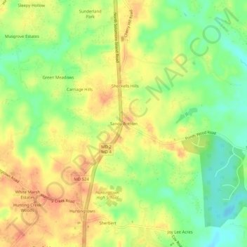
名称:Sandy Bottom地形图、海拔、地势。
地点:Sandy Bottom, Calvert County, Maryland, 20639, United States (38.61012 -76.62440 38.65012 -76.58440)
平均海拔:35 米
最低海拔:9 米
最高海拔:55 米
其他地形图
点击地图以查看其地形、其海拔和其地势。

点击地图以显示海拔。
名称:Sandy Bottom地形图、海拔、地势。
地点:Sandy Bottom, Calvert County, Maryland, 20639, United States (38.61012 -76.62440 38.65012 -76.58440)
平均海拔:35 米
最低海拔:9 米
最高海拔:55 米
点击地图以查看其地形、其海拔和其地势。