
Kings Stanley地形图
点击地图以显示海拔。
关于这张地图
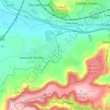
名称:Kings Stanley地形图、海拔、地势。
平均海拔:93 米
最低海拔:15 米
最高海拔:236 米
其他地形图
点击地图以查看其地形、其海拔和其地势。
Alderley
United Kingdom > England > Gloucestershire > Stroud
In A Topographical Dictionary of England by Samuel Lewis published in 1831, Alderley is described thus.
平均海拔:95 米
Jubilee Playing Field & Athletics Track
United Kingdom > England > Gloucestershire > Stroud > Cam > Draycott
平均海拔:45 米