
Tuckerton地形图
点击地图以显示海拔。
关于这张地图
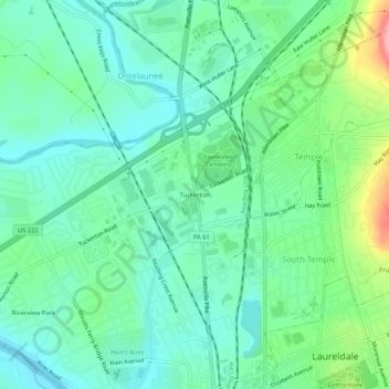
名称:Tuckerton地形图、海拔、地势。
平均海拔:101 米
最低海拔:67 米
最高海拔:197 米
其他地形图
点击地图以查看其地形、其海拔和其地势。
Temple
United States > Pennsylvania > Berks County > Muhlenberg Township
Temple is a census-designated place in Muhlenberg Township, Berks County, Pennsylvania, United States at an elevation of 361 feet (110 m). The community was named for a local inn called Solomon's Temple. Temple was an independent borough until it was disincorporated on January 1, 1999. The ZIP code is 19560.…
平均海拔:126 米