
Bhojpur地形图
点击地图以显示海拔。
关于这张地图
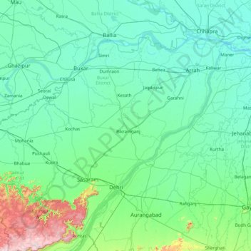
名称:Bhojpur地形图、海拔、地势。
地点:Bhojpur, Rohtas District, Bihar, India (24.55000 83.55000 25.95000 84.95000)
平均海拔:104 米
最低海拔:44 米
最高海拔:635 米
其他地形图
点击地图以查看其地形、其海拔和其地势。
Manihari
Manihari is located at 25°21′N 87°38′E / 25.35°N 87.63°E / 25.35; 87.63. It has an average elevation of 31 m (101 feet). This place is well known for the Manihari ghat, which connects it to Sakrigali Ghaat, which is situated on the southern bank of the River Ganges.
平均海拔:28 米