
Chillerton地形图
点击地图以显示海拔。
关于这张地图
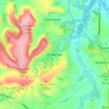
名称:Chillerton地形图、海拔、地势。
地点:Chillerton, Isle of Wight, England, PO30 3ER, United Kingdom (50.63255 -1.33069 50.67255 -1.29069)
平均海拔:76 米
最低海拔:18 米
最高海拔:167 米
其他地形图
点击地图以查看其地形、其海拔和其地势。
Lake
United Kingdom > England > Isle of Wight
Lake is a seaside village situated above the cliffs on Sandown bay, it stands at an elevation of 63 feet (19 m) above sea-level. Lake's beach or 'Welcome Beach' has golden sands and reached by a steep path down the sandstone cliffs to the Revetment. It has two cafes (Hinks and Strollers), beach huts, a Sea…
平均海拔:13 米
Ventnor
United Kingdom > England > Isle of Wight
Ventnor's landmarks arise from its natural environment, its Victorian heritage, and its tourist appeal past and present. Although modest in altitude at 241 metres (791 ft), the chalk St Boniface Down is 1⁄2 mile (0.80 km) north of the town. The downs have a thick layer of acid flint gravels, with dry…
平均海拔:58 米
Bembridge
United Kingdom > England > Isle of Wight
Close to the lifeboat station lies a coastguard lookout. Positioned at a high elevation, this offers views of the Solent meeting the English Channel to the east of the Isle of Wight. From this vantage point one is able to view a variety of watercraft year round, although there is more marine traffic in the…
平均海拔:9 米