Ullared地形图
点击地图以显示海拔。
关于这张地图
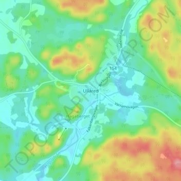
名称:Ullared地形图、海拔、地势。
地点:Ullared, Falkenbergs kommun, Halland County, 311 60, Sweden (57.11610 12.69558 57.15610 12.73558)
平均海拔:97 米
最低海拔:62 米
最高海拔:176 米
其他地形图
点击地图以查看其地形、其海拔和其地势。

点击地图以显示海拔。
名称:Ullared地形图、海拔、地势。
地点:Ullared, Falkenbergs kommun, Halland County, 311 60, Sweden (57.11610 12.69558 57.15610 12.73558)
平均海拔:97 米
最低海拔:62 米
最高海拔:176 米
点击地图以查看其地形、其海拔和其地势。