
Mount Crillon地形图
点击地图以显示海拔。
Mount Crillon
Mount Crillon is not climbed frequently, since it is an extremely challenging climb for its elevation due to its isolation. The first ascent was in 1934, by explorer Bradford Washburn on his third attempt, and longtime editor of the American Alpine Journal H. Adams Carter. They climbed via the East Ridge above the Plateau, reaching the summit on 19 July 1934.
关于这张地图
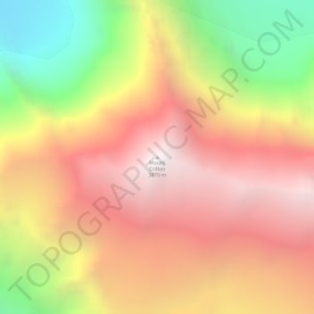
名称:Mount Crillon地形图、海拔、地势。
地点:Mount Crillon, Unorganized Borough, Alaska, United States (58.66266 -137.17186 58.66276 -137.17176)
平均海拔:2,891 米
最低海拔:1,606 米
最高海拔:3,862 米
其他地形图
点击地图以查看其地形、其海拔和其地势。
Chevak
United States > Alaska > Unorganized Borough
Chevak first appeared on the 1940 U.S. Census as an unincorporated native village. At the time it was located above the junction of the Keoklevik & Kashunuk Rivers at an altitude of 7 feet. 61°25′56″N 165°27′03″W / 61.43222°N 165.45083°W / 61.43222; -165.45083 (Old Chevak) In the 1940s,…
平均海拔:8 米
Nikolai
United States > Alaska > Unorganized Borough
Farewell Lake is a weather station roughly 38 miles south of Nikolai, at an elevation of 1060 ft (323.1 m). Farewell Lake has a subarctic climate (Köppen Dfc).
平均海拔:132 米
Paxson
United States > Alaska > Unorganized Borough
Paxson has a continental subarctic climate (Köppen Dfc), closely bordering on an alpine climate (Köppen ET) due to its high elevation and northerly latitude, with only one month above the 50 degree isotherm.
平均海拔:1,015 米
Akiak
United States > Alaska > Unorganized Borough
The airport has a gravel runway in good condition, measuring 3,196 feet (974 m) long by 75 feet (23 m) wide, at an elevation of 30 feet (9.1 m). The strip provides chartered or private air access year-round. Arctic Circle Air Service, Grant Aviation, and Hageland Aviation offer passenger flight service. Snow…
平均海拔:5 米