点击地图以显示海拔。
名称:La Maison Rouge地形图、海拔、地势。
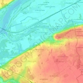
地点:La Maison Rouge, Villandry, Tours, Indre-et-Loire, Centre-Val de Loire, France métropolitaine, 37510, France (47.31835 0.48686 47.35835 0.52686)
平均海拔:63 米
最低海拔:35 米
最高海拔:98 米
点击地图以查看其地形、其海拔和其地势。
France > Centre-Val de Loire > Indre-et-Loire > Villandry > Le Château
平均海拔:64 米