Mahon地形图
点击地图以显示海拔。
关于这张地图
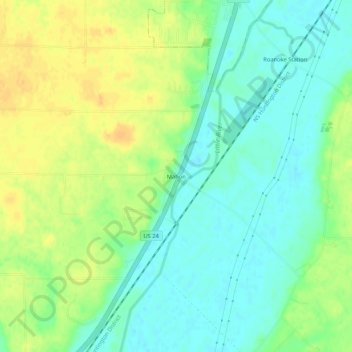
名称:Mahon地形图、海拔、地势。
地点:Mahon, Huntington County, Indiana, United States (40.91866 -85.40053 40.95866 -85.36053)
平均海拔:238 米
最低海拔:225 米
最高海拔:253 米
其他地形图
点击地图以查看其地形、其海拔和其地势。

点击地图以显示海拔。
名称:Mahon地形图、海拔、地势。
地点:Mahon, Huntington County, Indiana, United States (40.91866 -85.40053 40.95866 -85.36053)
平均海拔:238 米
最低海拔:225 米
最高海拔:253 米
点击地图以查看其地形、其海拔和其地势。