
Groot-Drakenstein地形图
点击地图以显示海拔。
关于这张地图
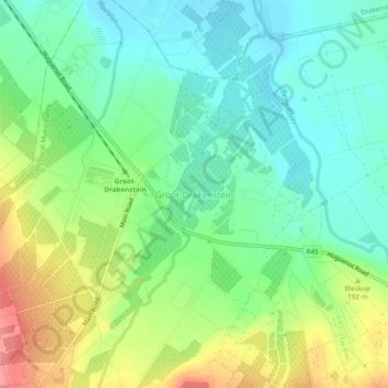
名称:Groot-Drakenstein地形图、海拔、地势。
平均海拔:173 米
最低海拔:140 米
最高海拔:235 米
其他地形图
点击地图以查看其地形、其海拔和其地势。
Stellenbosch
South Africa > Western Cape > Cape Winelands District Municipality > Stellenbosch Local Municipality
Stellenbosch is 53 km (33 mi) east of Cape Town via National Route N1. Stellenbosch is in a hilly region of the Cape Winelands, and is sheltered in a valley at an average elevation of 136 m (446 ft), flanked on the west by Papegaaiberg (Afrikaans: Parrot Mountain), which is actually a hill. To the south is…
平均海拔:287 米