Authon地形图
点击地图以显示海拔。
关于这张地图
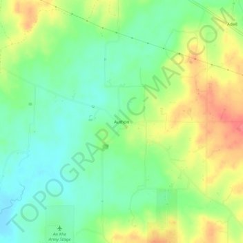
名称:Authon地形图、海拔、地势。
地点:Authon, Parker County, Texas, United States (32.84846 -97.96393 32.88846 -97.92393)
平均海拔:318 米
最低海拔:291 米
最高海拔:356 米
其他地形图
点击地图以查看其地形、其海拔和其地势。

点击地图以显示海拔。
名称:Authon地形图、海拔、地势。
地点:Authon, Parker County, Texas, United States (32.84846 -97.96393 32.88846 -97.92393)
平均海拔:318 米
最低海拔:291 米
最高海拔:356 米
点击地图以查看其地形、其海拔和其地势。