
Balsam Mountain地形图
点击地图以显示海拔。
关于这张地图
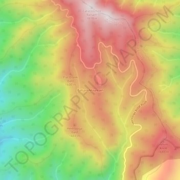
名称:Balsam Mountain地形图、海拔、地势。
地点:Balsam Mountain, Swain County, North Carolina, United States (35.54308 -83.19669 35.58308 -83.15669)
平均海拔:1,468 米
最低海拔:1,073 米
最高海拔:1,799 米
其他地形图
点击地图以查看其地形、其海拔和其地势。
Fontana Lake
United States > North Carolina > Swain County
Fontana Lake provides the only access into the most remote areas of the National Park, unless visitors undertake a multi-day hike to get there. When the lake is at the normal summer level, a boat may be used to access remote trailheads such as Hazel Creek. From the observation tower on Kuwohi, on a clear day…
平均海拔:806 米
Fontana Dam
United States > North Carolina > Swain County
Fontana Dam is 2,365 feet (721 m) long and 480 feet (146 m) high, making it the tallest dam in the Eastern United States. The dam has a flood storage capacity of 513,965 acre-feet (633,966,000 m3), and the combined capacity of its three generators is 293.6 megawatts. Fontana Lake has 238 miles (383 km) of…
平均海拔:525 米