
Vienna地形图
点击地图以显示海拔。
Vienna
Vienna is located in northeastern Austria, at the easternmost extension of the Alps in the Vienna Basin. The earliest settlement, at the location of today's inner city, was south of the meandering Danube while the city now spans both sides of the river. Elevation ranges from 151 to 542 m (495 to 1,778 ft). The city has a total area of 414.65 square kilometres (160.1 sq mi), making it the largest city in Austria by area.
关于这张地图
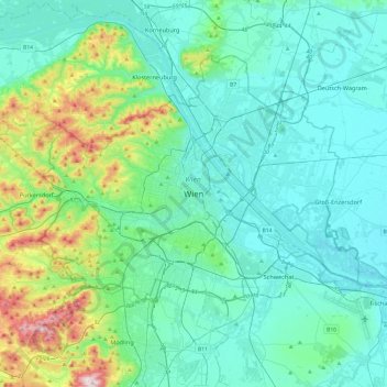
名称:Vienna地形图、海拔、地势。
地点:Vienna, 1010, Austria (48.04835 16.21250 48.36835 16.53250)
平均海拔:231 米
最低海拔:145 米
最高海拔:650 米