
Sitkum地形图
点击地图以显示海拔。
关于这张地图
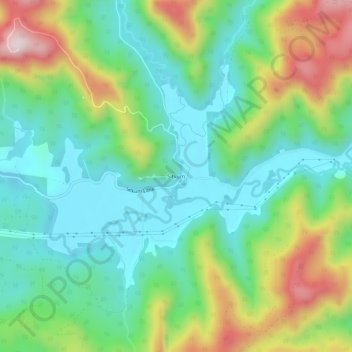
名称:Sitkum地形图、海拔、地势。
地点:Sitkum, Coos County, Oregon, United States (43.12817 -123.88120 43.16817 -123.84120)
平均海拔:336 米
最低海拔:166 米
最高海拔:690 米
其他地形图
点击地图以查看其地形、其海拔和其地势。
Coos Bay
United States > Oregon > Coos County
According to the United States Census Bureau, the city has a total area of 15.90 square miles (41.18 km2), of which, 10.60 square miles (27.45 km2) is land and 5.30 square miles (13.73 km2) is water. The city is quite hilly, with elevations ranging from between sea level to over 500 feet (150 m). Bodies of…
平均海拔:30 米