
Simikot地形图
点击地图以显示海拔。
Simikot
Lying at an altitude of just over 2,900m on a gentle slope high above the Humla Karnali River, Simikot lies on an ancient trade-cum-pilgrimage route to Mount Kailash. Mount Kailash is located in the Purang County of the Tibetan Autonomous Region, China, which borders Humla district of Nepal to the north. In the April 2015 Nepal earthquake, the popular Tatopani-Zhangmu route for the pilgrimage to Mount Kailash was badly damaged. In the aftermath of this earthquake the traffic for the annual pilgrimage to Mount Kailash shifted to Humla. Pilgrims would fly from Kathmandu to Nepalgunj, and then from Nepalgunj to Simikot. At Simikot, they would either spend a night in this village's few hotels, or would straightaway be taken in helicopter flights to Hilsa, from where they would cross into Tibet (China).
关于这张地图
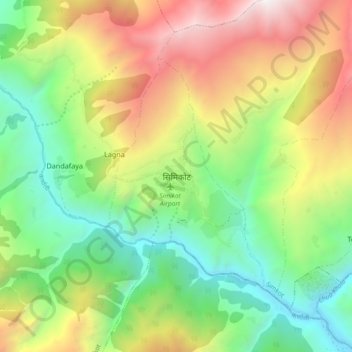
名称:Simikot地形图、海拔、地势。
地点:Simikot, Simkot, Humla, Karnali Province, Nepal (29.93286 81.78016 30.01286 81.86016)
平均海拔:3,100 米
最低海拔:2,071 米
最高海拔:4,678 米
其他地形图
点击地图以查看其地形、其海拔和其地势。