
Albert Park地形图
点击地图以显示海拔。
Albert Park
Heritage Victoria notes that Albert Park's St Vincent Gardens "is historically important as the premier 'square' development in Victoria based on similar models in London. It is significant as the largest development of its type in Victoria and for its unusual development as gardens rather than the more usual small park" and "was first laid out in 1854 or 55, probably by Andrew Clarke, the Surveyor-General of Victoria. The current layout is the work of Clement Hodgkinson, the noted surveyor, engineer and topographer, who adapted the design in 1857 to allow for its intersection by the St Kilda railway line. The precinct, which in its original configuration extended from Park Street in the north to Bridport Street in the south and from Howe Crescent in the east to Nelson Road and Cardigan Street in the west, was designed to emulate similar 'square' developments in London, although on a grander scale. The main streets were named after British naval heroes. The development of the special character of St Vincent Place has been characterised, since the first land sales in the 1860s, by a variety of housing stock, which has included quality row and detached houses and by the gardens which, although they have been continuously developed, remain faithful to the initial landscape concept."
关于这张地图
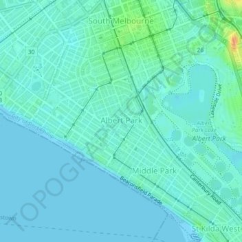
名称:Albert Park地形图、海拔、地势。
平均海拔:6 米
最低海拔:0 米
最高海拔:36 米
其他地形图
点击地图以查看其地形、其海拔和其地势。
Yarra Valley
Australia > Victoria > Melbourne
The Yarra Valley is the region surrounding the Yarra River in Victoria, Australia. The river originates approximately 240 km (150 mi) east of the Melbourne central business district and flows towards it and out into Port Phillip Bay. The name Yarra Valley is used in reference to the upper regions surrounding…
平均海拔:305 米
Dandenong Ranges
Australia > Victoria > Melbourne
The topography consists of a series of ridges dissected by deeply cut streams. Sheltered gullies in the south of the range are home to temperate rain forest, fern gullies and mountain ash forest Eucalyptus regnans, whereas the drier ridges and exposed northern slopes are covered by dry sclerophyll forest of…
平均海拔:456 米
Mount Dandenong
Australia > Victoria > Melbourne
Mount Dandenong has a cool oceanic climate (Cfb), with cool to mild summers and cold, damp winters. Daytime temperatures are usually 4−6 °C cooler than downtown Melbourne due to its elevation and distance from the urban heat island effect of Melbourne. It is significantly cloudier than Melbourne,…
平均海拔:395 米
Dandenong Ranges
Australia > Victoria > Melbourne
The topography consists of a series of ridges dissected by deeply cut streams. Sheltered gullies in the south of the range are home to temperate rain forest, fern gullies and Mountain Ash forest Eucalyptus regnans, whereas the drier ridges and exposed northern slopes are covered by dry sclerophyll forest of…
平均海拔:456 米